One <lateralProfile><shape> record: at station s, the road surface height relative to the elevation profile is a cubic polynomial in (t - t_record), valid from t_record until the next record at the same station. More...
#include <RoadInfoLateralShape.h>
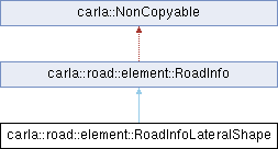
 Inheritance diagram for carla::road::element::RoadInfoLateralShape:
Public Member Functions | |
| void | AcceptVisitor (RoadInfoVisitor &v) final |
| double | Evaluate (const double t) const |
| Evaluate the surface height offset at lateral position t (the polynomial is defined over t - t_record). | |
| const geom::CubicPolynomial & | GetPolynomial () const |
| double | GetT () const |
| RoadInfoLateralShape (double s, double t, double a, double b, double c, double d) | |
| Public Member Functions inherited from carla::road::element::RoadInfo | |
| double | GetDistance () const |
| Distance from road's start location. | |
| virtual | ~RoadInfo ()=default |
Private Attributes | |
| const geom::CubicPolynomial | _shape |
| const double | _t |
Additional Inherited Members | |
| Protected Member Functions inherited from carla::road::element::RoadInfo | |
| RoadInfo (double distance=0.0) | |
Detailed Description
One <lateralProfile><shape> record: at station s, the road surface height relative to the elevation profile is a cubic polynomial in (t - t_record), valid from t_record until the next record at the same station.
Together the records describe the road cross-section (crown, banking); reconstructed real-world maps rely on them for crossing roads to agree on surface height inside junctions.
Definition at line 22 of file RoadInfoLateralShape.h.
Constructor & Destructor Documentation
◆ RoadInfoLateralShape()
|
inline |
Definition at line 25 of file RoadInfoLateralShape.h.
Member Function Documentation
◆ AcceptVisitor()
|
inlinefinalvirtual |
Implements carla::road::element::RoadInfo.
Definition at line 36 of file RoadInfoLateralShape.h.
◆ Evaluate()
|
inline |
Evaluate the surface height offset at lateral position t (the polynomial is defined over t - t_record).
Definition at line 46 of file RoadInfoLateralShape.h.
References _shape, and carla::geom::CubicPolynomial::Evaluate().
Referenced by carla::road::Road::GetLateralShapeZ().
◆ GetPolynomial()
|
inline |
Definition at line 50 of file RoadInfoLateralShape.h.
References _shape.
◆ GetT()
|
inline |
Definition at line 40 of file RoadInfoLateralShape.h.
References _t.
Member Data Documentation
◆ _shape
|
private |
Definition at line 58 of file RoadInfoLateralShape.h.
Referenced by Evaluate(), and GetPolynomial().
◆ _t
|
private |
Definition at line 56 of file RoadInfoLateralShape.h.
Referenced by GetT().
The documentation for this class was generated from the following file: